Quick start guide
FIND a spot
Search Google Places: Use Google Places to find a location you know (country, city, POI, etc.). This search is independent of the search for spots from ParaglidingSpots.
Search PGS database: Do a text search on the ParaglidingSpots database. You can choose whether you want to search only for the spot names or the entire database.
Search in continent or country: Narrow your search in the ParaglidingSpots database to a continent or country.
Search placemarks by type: Select which of the placemark types should be taken into account in the search result.
Search placemarks by rating: For takeoffs, you can also limit the search results to the rating of these points.
Attention: Many countries still do not have ratings. All takeoffs in Europe have a rating. In addition to Europe, the countries Canada, USA, Chile, New Zealand, South Africa, Algeria and Japan also have ratings for takeoffs.
Results: When you click on the name in the results list, the point will be shown on the map. For more information about the point, click on the point.
FILTER spots
Filter continent or country: Show the placemarks on the map only for a continent or country.
Filter around location spot: Only the points within the selected radius (km) around your location or around the location you selected are displayed (red pulsing dot).
Filter placemarks by type: Select which of the placemark types to display on the map.
Show takeoffs with rating: You can limit the display of takeoff placemarks to a rating between 0/6 and 6/6.
Feedback form
Please fill out the complete form. All fields are required!
Your input is valid
Your input isn't valid or you left the field blank
The following takeoff types are possible
| - | TO (Takeoff Hill/Mountain) | |
| - | TOC (Takeoff Coast) | |
| - | TOW (Takeoff Winch) | |
| - | LZ (Landing Zone) | |
| - | TH (Training Hill) | |
| - | Annex -HG (Hang Glider) |
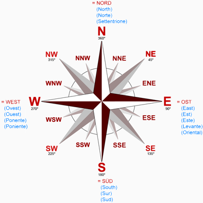
The takeoff orientation is taken from the compass rose and is placed in brackets. Note:
- e.g. (N-W) means north to west
- e.g. (N,SW) indicates north or southwest.

- e.g. (N-W) means north to west
- e.g. (N,SW) indicates north or southwest.

Different takeoff names are possible.
The names must be seperated by an underscore or alternative names are placed in brackets.
The names must be seperated by an underscore or alternative names are placed in brackets.
A paraglidingspot placemark location is defined by coordinates in the WGS84 format (see Wikipedia).
You can specify the latitude and longitude in three different formats. Please use the appropriate fields for this.